Description
The Downtown Woody Point Registered Heritage District is located in the historic downtown area of Woody Point, a small town located in Bonne Bay on the west coast of Newfoundland and Labrador. It is located in the heart of Gros Morne National Park, surrounded by fjords, mountains and green, hilly terrain. The district boundaries run from 2 Water Street north to 54 Water Street; from the intersection of Water Street and Blanchard’s Road, along the entirety of Blanchard’s Road, west to the intersection of Main Street; from the intersection of Blanchard’s Road and Main Street running south to the intersection of Main Street and Water Street; from this intersection running east to 2 Water Street. The entire block forms a general square shape and includes residences, commercial properties, a lighthouse, a Loyal Orange Lodge, churches, fisheries premises, and a war memorial, as well as greenspace, flora and fauna, and a portion of the coastline. The district shows the evolution of the town’s main commercial district, which began in the late 1880s, much of which was destroyed due to a catastrophic fire in 1922, and the rebirth of the town post-1922.
Statement of Significance
Formal Recognition Type
Registered Heritage District
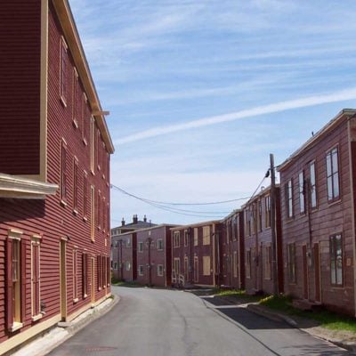
Heritage Value
The Downtown Woody Point Registered Heritage District has been designated for its aesthetic and historic values. Woody Point takes its name from a point of land that juts into Bonne Bay and historically provided sheltered, deep water anchorage. Woody Point was the site of the earliest English trading post in Bonne Bay, Bird and Company, operated by the Joseph Bird Firm, from Dorset. The municipal boundaries expand well beyond the downtown area, but it was the waterfront that saw commercial enterprise thrive. The Woody Point branch of Bird and Company dealt chiefly in salmon and furs and apart from Bird’s agent there were no year-round inhabitants. Local tradition identifies John Roberts as the first settler of Woody Point, having moved there from nearby Rocky Harbour circa 1849. About that same time other settlers began populating the nearby area and the Jersey firm of DeGrucy, Renouf, Clement and Co. purchased Bird and Co’s Woody Point fishing room. By the early 1870s new settlers began inhabiting Bonne Bay in pursuit of the Labrador fishery and a thriving winter herring fishery. Many of these settlers came from other parts of Newfoundland but some came from Nova Scotia in pursuit of lobster. Woody Point became the mercantile and administrative centre for Bonne Bay and the upper St. Barbe coast until the 1940s. It had a busy harbour, customs house, courthouse, post office and many private, retail businesses. However, this changed in 1922 when the entire waterfront of Woody Point was engulfed by fire, destroying wharves, retail sheds, coal sheds and warehouses belonging to merchant firms such as George Prebble, David Coen, Thomas Garcin, and the Butt Brothers. Also burned were the customs house, government warehouse, post office and courthouse bringing to a total 58 buildings lost. Following this tragic event many of the businesses either reduced their operations, or ceased to exist at all. To compound this loss, the growth of west coast community Corner Brook with its mill and new hospital, and the Deer Lake power project drew businesses and residents away from this former capital. The Downtown Woody Point Registered Heritage District is the combination of two eras in the history of this community. The district reveals the distinct separation between two points in time through the architecture of the buildings. The pre-1922 era buildings and landscape layout reveal styles typical for that time period. Buildings such as the Lord Nelson Loyal Orange Lodge #149, John William Roberts House and Hezekiah House are indicators of this era, with classical revival vernacular styles. The steep gable roofs and front peaks, and the massing and architectural details of the LOL reveal the prosperity of the town at that time. The downtown area, which was rebuilt after 1922, reveals structures from that era, indicated by their simple forms and general lack of ornamentation, some with large storefront windows, some with boomtown facades, while others are converted fishing stores; and many residences are constructed similarly, as two-storey biscuit box style. The close proximity of buildings to each other gives the feeling of a “downtown” or main street mixed commercial and residential area. The use of green space is varied, though a large meadow is the central natural area within the district. Together with its harbour front setting, this district bespeaks its early commercial and residential beginnings, and its evolution after the fire. Source: Heritage Foundation of Newfoundland and Labrador, Meeting Held November 7, 2008, Minutes #62.
Character Defining Elements
All those elements that embody the commercial and residential aspects of the late nineteenth-century and post-fire, early twentieth-century rural Newfoundland district, including: -its harbour-side location, encompassing a large meadow and including an upper road; -Those aspects of architecture which are indicative of this time period, including but not limited to the low pitch gable roofs, residential two storey construction, use of traditional materials such as wood, wide window and door trims, wooden siding, front peak design, and boomtown facades on commercial structures; -proximity of buildings to each other and their locations on the landscape; -those commercial structures which maintain their original storefront facades, including large picture windows and plain, unadorned exteriors with little architectural detail and sign bands; -variety of sizes of buildings, both commercial and residential which are suggestive of both time periods and give a clue of the area’s evolution and rebuilding after the fire; -lack of very tall structures and modern buildings; and -general cohesiveness of the buildings and their relationships to each other which helps to give the district its overall distinct appearance as a commercial streetscape surrounded by residences.
Location and History
Community
Woody Point
Municipality
Town of Woody Point
Civic Address
Main Street, Water Street, Blanchard's Road
Construction (circa)
19700101 - 19700101
Location
Similar Heritage Properties